Somehow, if the idea of walking around the imposing Mont Blanc massif has wormed its way into your brain, you have probably found yourself here, reading up about the tour du mont blanc standard route and important sights along the way, along with this we will throw our top tips on how you might accomplish it all.
This is the first of our 2 part Tour du Mont Blanc guide. You can skip to the second part here.
The Tour du Mont Blanc (TMB) is perhaps one of the most coveted treks in Europe. The route runs through France, Switzerland and Italy through beautiful valleys and spectacular mountain passes. There are 11 stages usually starting and ending in Les Houches (just outside Chamonix) and accomplished across 10 days, with an average of 9hrs walking a day.
At the end of your trek you would have knocked off more than 160kms and accumulated 10,000m of altitude. The Tour du Mont Blanc has some variations, and being circular it can be done in either direction and from any start point, although the classic route would be to first set off from Les Houches heading to Les Contamines as in our itinerary below.
It is one of the most popular trails in Europe and the height never exceeds 3,000m. Therefore you need to be in good (and not exceptional) physical shape but you do not need any altitude training to enjoy it to the fullest!
Map of Tour du Mont Blanc available here.
Stage 1 Les Houches – Les Contamines: 19.57km
Accumulated ascent: 1835 m
Accumulated descent: 1130 m
Beginning with Les Houches to Col de Vosa, you can then decide if you want to get to Les Contamines via Bionnassay or the Refuge De Miage.
– Refuge de Miage
1560 m, Saint Gervais les Bains (FR)
Summer season: June/September. Contact: +33(0)4.50.93.22.91
1315m, Saint Gervais Les Bains (FR)
Summer season: June/ 28th September. Contact: +33(0)4.50.93.45.23
1164m, Les Contamines-Montjoie (FR)
Open all year. Contact: 04 50 47 02 44
On this stage:
You will pass five alpine villages on your way down from the Col de Vosa to the Montjoie valley. The villages of Bionnassay, le Champel, la Villette, la Gruvaz and Tresse are all perfect stops to stock up on artisanal cheese and saucisson to keep you going over the stages ahead.
Stage 2 Les Contamines – Les Chapieux/Refuge Des Mottets: 21.06km
Accumulated ascent: 1795 m
Accumulated descent: 2010 m
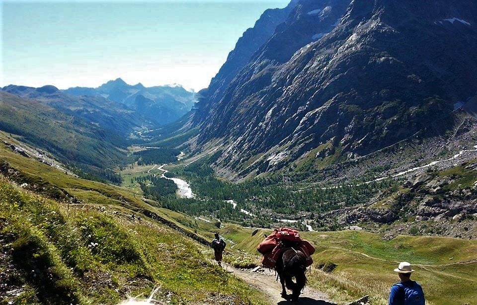
After Les Contamines you make your way to the col de la croix du bonhomme. From here you will ideally set off for La Ville des Glaciers via the Col des Fours. However a longer alternative route to La Ville des Glaciers exists by passing through Les Chapieux (add 4.59km). From the Ville des Glaciers you will make your way to your final destination for the night, the Refuge des Mottets.
1864m, Les Chapieux – Bourg Saint Maurice (FR)
Summer season: 10th June/19th September. Contact: +33(0)4.79.07.01.70
On this stage:
Take the time to discover the Notre-Dame de la Gorge church which marks the beginning of your alpine efforts. With its stunning multi-coloured façade this modest stone “eglise” awaits on the outskirts of Les Contamines, near the Refuge Nant Borrant.
Warning: This is known as the toughest stage, crossing the Col de la Croix du Bonhomme at 2,479m.
Stage 3 Refuge Des Mottets – Col de la Seigne – Rifugio Elisabetta: 7.70 km
Accumulated ascent: 600 m
Accumulated descent: 360 m
Crossing the border into Italy you could consider this a “rest day” in terms of Kilometres covered. Depending on what time your set off from Des Mottets you will be able to make the most of the stunning Rifugio Elisabetta as you relax and prepare for the long descent to Courmayeur the following day.
(we recommend you avoid the large 20-person dorm rooms for a better night sleep)
2185m, Val Veny – Courmayeur (I)
Summer season: June/September. Contact: +39(0)1.65.84.40.80
On this stage:
Cultured hikers may choose to continue another three hours (downhill) from the Rifugio Elisabetta for a night of luxury and culinary discovery at the Auberge de la Maison Alpine Resort and Spa. This Courmayeur location (just after Val Veny) has a stunning rear view of Mont Blanc and mixes modernity with authentic Italian alpine charm, much like their cuisine. Here you can shmooze your way from a hard handed Swedish massage to a soft pink lamb rack, while rubbing shoulders with moneyed mountaineers and Milano weekenders.
Stage 4 Rifugio Elisabetta – Courmayeur: 15.77km
Accumulated ascent: 1855 m
Accumulated descent: 2005 m
First you will set off 3.27KM to Val Veny, all along an ancient Roman road lined with lakes. Once at Val Veny you can decide to head to Courmayeur by way of the Rifigio Monte Bianco (1680m) and onward through Entreves. Alternatively, you can set off for Rifigio Maison Veille (1955) and traverse most of the (out of season) ski domaine to Courmayeur. The Maison Veille is well known to skiers as a fantastic pasta destination with large sunny terrace area and wide open views.
The end of this stage, and the start of stage 5 is considered the Alpine Museum of Courmayeur.
1700m, Val Veny – Courmayeur (I)
Summer season: June/September. Contact: +39.0165.86.90.97
1956m, Col Chécrouit – Courmayeur (I)
Summer season: 12th June/25th September. Contact: +39.337.23.09.79
On this stage:
When in Italy be sure to indulge in the risotto and polenta dishes which you won’t find elsewhere on your Tour. Maison Vielle in particular however, is well known for its delicious pasta dishes. For a night-cap try Grappa, made from the skins, seeds and stalks of grapes known collectively as “pomace”. Look out for the good stuff, “riserva”; Aged in wooden casks it will be yellow or brown-hued and glued to the hand of the oldest middle-mountain guide in sight.
Stage 5 Courmayeur – Rifuggio Bonatti: (distance depends on chosen route)
Accumulated ascent: 2790 m
Accumulated descent: 1845 m
From the Alpine Museum you will start your day with a 2.06km climb to Villair where you will decide from one of three routes to the Bonatti Refuge. We recommend the simple hike from Villair to Rifugio Bertone (rising a further 525m) to join the easier route (both climbing and descending roughly 300m altitude) to Rifugio Bonatti over 9.65km with an accumulated ascent of 865m, and descending 345m.
Alternatively you can combine routes 1 or 2 below with a final leg from Col Sapin to Rifugio Bonatti:
1. Via Val Sapin: 5.21 km, Accumulated ascent: 990 m, Accumulated descent: 25 m
2. Senterio Testra Bernada via Rifugio Bertone: 6.76 km, Accumulated ascent: 1115 m, Accumulated descent: 160 m
Then final leg: Col Sapin – Rifugio Bonatti: 5.65 km, Accumulated ascent: 230 m, Accumulated descent: 610 m
1970m, Mont de La Saxe – Courmayeur (I)
Summer Season: 10th June/30th Septembre. Contact: +39.0165.844.612
2025m, Val Ferret – Courmayeur (I)
Summer season: 15th May/September. Contact: +39.0165.86.90.55
1224m, Town Centre – Courmayeur (I)
Open all year. Contact: +39 0165 84 28 35
On this stage:
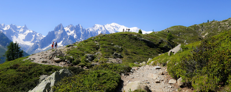
In clear weather the views from the Tete de la Tronche are exceptional; Jagged snow and rock peaks dominate the skyline here, with glaciers snaking their way down to the valley below. Also, calorie load on local cheese ‘Robiola’ creamy, spreadable deliciousness.
Warning: This is known as the second toughest stage!
Stage 6 Rifuggio Bonatti – La Fouly:18.76km
Accumulated ascent: 1650 m
Accumulated descent: 1690 m
This stage crosses the border from Italy to Switzerland via the Grand Col Ferret. Once you reach La Peule you will make your way to La Fouly via Ferret. If you do not want to stay the night in the village below, in more of a hotel ambience, you could stop in at Gite de la Lechere (found just after the crossroads of Dranse de Ferret and Le Merdenson trails).
1610m, La Fouly (CH)
Summer season: June/September. Contact: +41(0)27.783.30.64
1610m, La Fouly (CH)
Summer season: 1st June/22nd September. Contact: +41(0)27.783.26.21
2100m
Summer season: 15th June to 20th September
This refuge is just on the border of Italy and Switzerland with great food and views! It’s a dairy farm and a dormitory packed into one, which comes highly recommended by Milly from our resort team for the on-site dairy products they produce. With their 65 dairy cows, they make raclette cheese, tomme and alpine butter They also offer typical mountain dishes such as raclette, fondue and croûte au fromage.
On this stage:
La Fouly makes up in meadows and meandering rivers, what it lacks in granite peaks and Grappa. It’s a return to cow country and cheese dominates the menu once more…but this time it’s all melted! Fondue is back on the menu, as is fine Swiss chocolate.
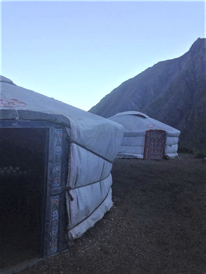
Yurts at the Auberge de la Peule
Stage 7 La Fouly – Champex: 16km
Accumulated ascent: 835 m
Accumulated descent: 985 m
Now it’s time for everyone’s favourite lake stage with 16 straight forward kilometres full of typical Swiss alpine culture as you pass each village.
1444m, Champex (CH)
Summer season: 7th June/26th September. Contact: +41(0)27.783.14.23
1466m, Champex (CH)
Open all year. Contact: +41 27 782 61 51
On this stage:
Enjoy calming, pastoral beauty over this relatively easy stage from La Fouly to Champex.
Stage 8 Champex – Buvette du Glacier or Col de la Forclaz/Trient
(distance and altitudes depend on your chosen route)
Chamonix is so close now you can almost smell the raclette, as during this stage you will make your way back to the French border!
The most direct route to the Buvette du Glacier is to head via the Fenêtre d’Arpette: 9.98km Accumulated ascent: 1165 m Accumulated descent: 1025 m
Or
An alternate route to consider would be set off to the via the Col de Forclaz (1527m) to your final destination in Trient Village (1300m) itself. Heading towards Champex d’en Bas (1340m) you would climb to Bovine (1987m) and onwards to the Col. The descent to the famous pink church in Trient will take you a further 40minutes (3km).
(here you can book a night in a “Tipi”)
1605m, Glacier du Trient (CH)
Summer season: June/September. Contact: +41 79 635 96 44
1526m, (on the route down to) Trient (CH)
Open all year. Contact: +41(0)27.722.26.88
1300m, Trient village centre (CH)
Summer Season: June/September. Contact: +41(0)27.767.15.05
On this stage:
The Fenêtre d’Arpette, the highest point of the tour at 2,665m is waiting to reward you. As soon as you’re looking down on the Trient glacier a warm peach coloured church lies below where the Auberge du Mont Blanc will likely host you. At the Auberge their most famous dish is also peach in colour; a creamy tomato fondue.
Stage 9 Buvette du Glacier – Tré-le-Champ: 12.19km
Accumulated ascent: 875 m
Accumulated descent: 1050 m
(If in the last stage you opted to stay in Trient, then you will climb 305m up to the Buvette du Glacier over 3.18 km to start.)
France and the home stretch to Chamonix beckons! First you will climb to the Chalet du Col du Balme at 2191m. From here you will descend the (out of season) ski domaine of Balme/Le Tour (keeping an eye out for Mountain Bikers sharing the trails). Once you reach the base of the ski slopes (La Vormaine) you can decide to cut your hike short, eat and stay at the L’Olypique (just by the departure of the Charmillion telecabine) Tour or continue on to the Auberge La Boerne at Tré-le-Champ Le Bas.
2190m, Le Tour – Chamonix (FR)
Summer season: June/September. Contact: +33 (0)6 07 06 16 30
1464m, Le Tour, La Vormaine – Chamonix (FR)
Open all year. Contact: +33 (0) 4.50.54.01.04
1395m, Tré-le-Champ Le Bas – Chamonix (FR)
Open all year. Contact: +33 (0) 4 50 54 05 14
Some hungry hikers will head straight on to Stage 10…
On this stage:
Once thought to be the home of demons, regularly exorcised by local clergymen, take your mindset back to the 1800’s as you marvel at the three glaciers visible over the course of this hike. From the Buvette du Glacier (Trient Glacier) to the Glaciers du Tour and Argentiere there is plenty of impressive ice on display, but during the “Petite Ice Age” there would have been much much more! Learn about the history of ancient ice exploitation from Treint here.
Stage 10 Tré-le-Champ – Refuge La Flégère: 6.73-7.65km
(altitudes depend on your chosen route)
If you’re ready to climb 645m to the Tête Aux Vents then the second half of your stage will be much easier. Choose from:
1. (easier) La Tête Aux Vents – Refuge La Flégère: 3.6km Accumulated ascent: 105 m, Accumulated descent: 360 m
2. (harder) Tête Aux Vents – Lac Blanc – Refuge La Flégère: 4.52km Accumulated ascent: 235 m, Accumulated descent: 505 m
Both routes will get you the Refuge for your nights rest, however the second option will allow you to stop in at the iconic Lac Blanc (which is also home to quite an exclusive refuge, you will be lucky to get a booking here but may at least enjoy lunch during the high season).
2352m, Chamonix (FR)
Summer season: June/September. Contact +33(0)6.02.05.08.82
1877m, Chamonix (FR)
Summer season: June/September. Contact: +33(0)6.03.58.28.14
On this stage:
Stunning Lac Blanc will give you one of the most impressive views of the Chaine du Mont Blanc directly opposite your position. On a calm day the outline may be perfectly reflected in the water, which is precisely why it makes our list of the best photography spots in the valley here.
Final Stage: (Balcon Sud) Refuge La Flégère – Le Brévent – Les Houches (16km)
Accumulated ascent: 1070 m
Accumulated descent: 1905 m
The final leg leads you across the famed “Balcon Sud” to your original starting village of Les Houches. During this route you will probably encounter the most people since when your journey began, and is a return to “civilisation” with bustling Chamonix beckoning from the valley below and an exceptional view across the Chaine du Mont Blanc, which you have just traversed.
On this stage:
Again be sure to take in the views of Mont Blanc as you complete your trek. Far across the deep Arve valley between the snaking Mer de Glace and Les Houches (your final destination) the panorama from Le Brevent at 2,525m will be sure to fill you with emotion.
You did it! Now time to celebrate, pick from your accommodation choices in Les Houches – Chamonix here.
To read on about some of the practicalities of taking on the tour read Part 2 of our TdMB guide.